We are living in a time where technology is increasingly becoming a part of our daily lives, even in aspects we might not consciously notice. A clear example of this is the reliance that a significant portion of society has developed on GPS, a tool that proves extremely useful for navigating to specific locations. Just a few years ago, people depended on other elements to find their way, such as street names, paper maps, or simply their intuition to determine the right direction. Nowadays, the ability to locate ourselves in space is much simpler, thanks to smartphones equipped with GPS. In the case of Android or iOS devices, the tool used is Google Maps.
The usage dynamics of this platform are straightforward; you simply search for the address or location you want to navigate to, and the application guides you with details (indicating the direction, distance, upcoming turns, estimated time of arrival, among other details). This makes it an incredibly useful tool that is increasingly embraced by users, earning the title of the leading platform in location services.
Despite the simplicity of using this app, there are still many people who have not fully adapted to these technological changes and continue with traditional methods. However, this often stems from a lack of clarity on how to perform searches or follow the instructions provided by the voice guidance. It all starts with the search and details about the time and distance from our current location to the desired destination. Therefore, in this tutorial, we will provide a detailed guide on how to determine the distance from my location using Google Maps and how to perform a search with the functionalities.
How to get there and determine distance from my location with Google Maps?
Step 1: Open the Google Maps application
The beginning of the process of figuring out the distance to a location from Google Maps starts with the initial search, and this needs to be carried out from the application. Although there is another alternative, which is to search in the Google browser and select the map option, we believe the best choice is to do it directly in the app from the beginning. Therefore, the first action we need to take is to open the Google Maps application by tapping on the Google icon, usually located on the smartphone’s home screen.
When we tap on the Google button, all the factory-installed apps on devices with this operating system open up, such as Gmail, YouTube, Drive, Google TV, among others. In this case, we need to select the one that says maps from Google.
Step 2: Conduct the search

Once inside the app, the first thing we need to do is specify the place we want to reach. Everything starts with this search, determining not only the route we should follow but also knowing how long it will take to reach a place we need to go. At the top of the screen, a white bar that says ‘Search here’ is visible, and that is the search bar we need to use. In this initial stage, we will have to type in the destination we want to reach. If it’s a city or town, we simply need to enter the name, and if we have the address, we also need to type that in. There are cases where we don’t know the exact name or address of the site, but we can search by any other data since the search is quite intelligent and can still help us find the correct destination.
Step 3: Choose the indicated destination
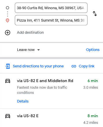
Once we have entered the details of the place we need to go, a dropdown menu opens just below the search bar with different result options from the search we conducted. It is crucial to pay close attention at this step since various options are presented, and not all may lead to the same place. Therefore, it is very important that we are sure the choice is correct. In other words, what we need to do at this stage is press on the correct option that corresponds to the location we need to reach.
Step 4: Tap on the start option
When we select the place found in the previous search, we have fulfilled the initial objective: knowing how far I am from the place I want to reach, and also knowing how long it will take to get to that place. The app provides this information at that moment, as a preview before starting to indicate the routes we need to follow. Some important details to consider are that at the top of the screen, we have the possibility to make certain adjustments. It is crucial that the starting point says ‘Your location’ or an address you select in the map as the starting place as this way, the app guides us to reach from the place you choose or where you are at that moment. It is also key that the mode of transportation is correct, as often the route and times change depending on whether we are driving, walking, using public transport, etc.
To continue with the process and get the specification of the route to follow, we need to tap on the button that says ‘Start.’ However, we can also press the blue one that says ‘Directions’ to see more details and then tap on the previously mentioned option since it is also available on that screen.
Step 5: Follow the directions
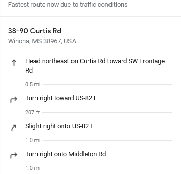
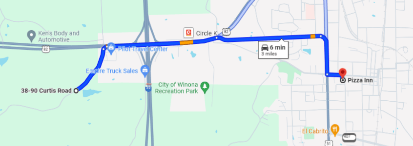
After completing Step 4, the application itself starts guiding us about the route we need to take to reach our destination. In other words, all we have to do is follow those directions. These can be given with sound through the app’s voice (if we want to mute the sound, we simply press the headphone button) or by following the blue arrow that guides us.